A storm is heading toward the Boston area and is expected to bring rain, wind and snow to parts of Massachusetts Wednesday into Thursday. Here are the latest forecasts from the WBZ NEXT weather team.
BOSTON – Highly destructive and long-lasting storm systems bring different types of precipitation and impacts. Or, simply put, the next few days are going to be dire.
winter storm warning
The National Weather Service issued a winter storm warning for northern Worcester County and far northwestern Middlesex County for Wednesday and Thursday.
CBS Boston
A winter storm warning is currently in effect across southern Vermont, New Hampshire, and Maine. These areas are at high risk of further accumulation of snow.
In addition, the NWS has issued a coastal flood advisory for Thursday morning's high tide cycle.
CBS Boston
When will the storm arrive?
Little to no rain is expected on Wednesday morning, but the rain will increase in intensity in the afternoon and evening.
The biggest concerns regarding wind, flooding and winter precipitation are in the overnight time frame through Thursday.
CBS Boston
Again, Wednesday morning looks mainly dry, with perhaps a few light showers approaching around midday.
The rain will begin to progress considerably in the afternoon and will be widespread by the evening commute.
There will be some sleet in places, mainly northwest of Route 495.
CBS Boston
At night, a bit of colder air moves in above, and the sleet turns to snow.
By dawn Thursday, most areas north of the Massachusetts Turnpike will see snow, while the south will see continued rain.
The difficult part is determining how much of an impact this snow will have. Given that it is raining on a fairly warm surface during the day in April, it would be difficult for it to accumulate.
CBS Boston
Temperatures fall below freezing, typically between 33 and 36 degrees in snowy areas. Deposition on roads will be the most difficult. You'll probably see snow on the grass in front of the road, and it's always the same at higher elevations.
It's really hard to put all this on a snow forecast map…even very short distances will make a very noticeable difference. Even within a single town with varying elevations (hills and valleys), accumulations can vary by several inches.
How much snow does it get in Massachusetts and New Hampshire?
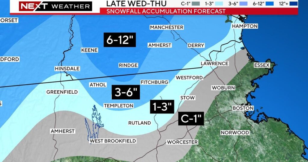
No accumulation is expected in the Boston area or inside Route 128, but there is a chance of occasional flurries of wet snow.
Almost all of the rain will fall in southeastern Massachusetts and all areas south of the Mass Pike.
CBS Boston
From north and west of Highway 128 to approximately Highway 495, there should be some deposits on the surface. That's probably enough to scatter up to an inch of coating.
As much as 1 to 3 inches of rain could be present north and west of 495 County, including northern Middlesex and Essex counties, again more on grass than roads.
High-elevation areas of northern Worcester County and northwestern Middlesex County are expected to receive 3 to 6 inches of pasty, wet snow.
As much as 6 to 12 inches of rain could fall in the high mountains of southwestern New Hampshire.
Possibility of power outage due to heavy snow
Snow is heavy and can be dangerous if it accumulates on tree branches. Combine this with the forecast for high winds, and there's a good chance there will be numerous power outages in areas with heavy snowfall.
A shield of snow will advance northward during Thursday afternoon as the center of the storm moves across southern New England. Snow could linger for several hours Thursday afternoon and evening in northern Middlesex and Essex counties.
Unfortunately, the storm won't be leaving our area anytime soon. We'll be stuck in the clouds with rain on and off through Friday and Saturday.
This is very low-impact, but still annoying.
wind, coastal flooding
Winds will pick up Wednesday afternoon and evening, reaching their strongest overnight into Thursday morning.
Frequent easterly winds of 30 to 50 mph are expected throughout the region. Along the immediate coastline, the National Weather Service issued a high wind warning, with wind gusts as high as 60 mph possible.
CBS Boston
As the center of the storm moves across southern Massachusetts during the day Thursday, winds will weaken significantly in southeastern Massachusetts, but winds will eventually pick up again along the northeastern Massachusetts, New Hampshire, and Maine coastlines.
We are particularly concerned about the area from Cape Ann to Salisbury to Hampton, N.H., which has been hit multiple times over the past few months.
CBS Boston
These areas may experience mild to moderate flooding in addition to renewed coastal erosion.


