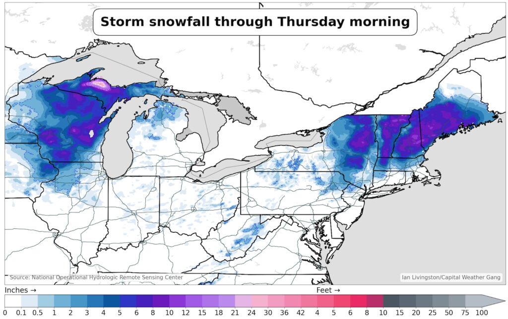
The same storm dumped 1 to 2 feet of snow in parts of northern Wisconsin and Michigan's Upper Peninsula on Tuesday and Wednesday, knocking out power to more than 150,000 customers as its weight snapped trees and power lines.
A somewhat prolonged storm will begin in the Northeast on Wednesday and will not fully subside in parts of New Hampshire and Maine until Friday night or Saturday.
The snow comes on the cold side of a powerful and widespread storm system that has hit the country. After heavy rain, flooding and snow fell across California over the weekend, severe thunderstorms hit central and eastern states earlier in the week.
Satellite images show a huge vortex of low pressure over Ohio. This caused a cold front to pass over the East Coast, forming a new low pressure system along it south of Long Island. This is pushing moisture back toward the coast like a windmill, while simultaneously drawing colder air south. That frigid air mass poured into the mountains of Massachusetts, dumping a wintry mix. Further north, sleet turned to wet, heavy snow.
I have summarized the amount of snowfall so far.
- 15.2 inches in Greensboro, Vermont
- 13.5 inches in Rochester, Vermont
- 12.2 inches in Porter, Maine
- 12.1 inches located in Hollis, Maine
- 12 inches in Eden, Vermont
- 11.5 inches in Warren, Vermont
- 11 inches in Deerfield, New Hampshire
- 8.2 inches in Plainfield, Massachusetts.
- 8 inches in Conway, New Hampshire
- 6 inches in Portland, Maine
Moisture surrounding the ongoing storm will continue to dump snow across much of northeastern New York, Vermont, New Hampshire, northern Massachusetts, and Maine (primarily west of I-95) through Thursday evening. Dew. An additional 3 to 5 inches is possible in the heaviest zones.
By Thursday night, the center of the low pressure system will pull into Maine, drawing a milder oceanic air mass into the state and bringing snow to interior central Maine, potentially turning into freezing rain or a wintry mix. . Snow will be intermittent in Vermont and New Hampshire, but steady in western and northern Maine.
Snow could continue to fall in inland Maine Friday into Friday night as the center of the low pressure system snakes near the coast. Scattered snow is possible in the mountains of Vermont, New Hampshire and New York, as well as downwind from Lakes Ontario and Erie.
Precipitation could change to rain Friday in eastern Maine and along the coast, but could briefly switch back to snow early Saturday before the low pressure system finally moves eastward.
Strong winds and coastal flooding
The storm produced high winds, including gusts of 91 mph on Nantucket and 58 mph in Hyannis. Wind gusts were recorded at 59 mph in Boston and 54 mph in Provincetown at the tip of Cape Cod.
Wind gusts as high as 53 mph occurred at the Portland International Jetport in Maine, with some gusts of 60 to 70 mph along the coast.
Strong winds are pushing water onto the coastline. Water levels in Boston are 3.9 feet above normal, and the Outer Cape has seen a rise of 2.3 feet so far.
Widespread areas of 5 to 10 inches of rain fell across much of Wisconsin, while totals rose to about 12 to 18 inches in highlands near Marquette in Michigan's Upper Peninsula. Much of the heavy snowfall occurred Tuesday night into early Wednesday.
Marquette received 14 inches of rain on April 2 alone, nearly double the 2016 lunar day record of 7.2 inches. Green Bay saw an increase of 6.5 inches of precipitation, including a record of 5.1 inches on April 2nd. Precipitation totals from this single storm exceeded the monthly average. Green Bay was close to average, Marquette was close to average.
Additional storm snowfall totals are:
- 14.2 inches in East La Crosse, Wisconsin;
- 14 inches in Ishpeming, Michigan (southwest of Marquette)
- 12 inches in Herman, Michigan (west of Marquette)
- Caledonia, Minnesota (southwest of La Crosse) 8 inches
- 6.8 inches in Escanaba, Michigan (along the north shore of Lake Michigan)
- 6.5 inches in Dubuque, Iowa
- 4 inches in Freeport, Illinois.


