Winter storm warnings are in effect for Denver and Boulder, with double-digit snowfall expected, likely the heaviest snowfall from a single storm since 2021. Continued rain on Wednesday is expected to turn to snow by night, followed by heavy snowfall.
The National Weather Service, which covers the Denver-Boulder area, predicts the wet snow could damage trees and power lines. The office also warned of “difficult or nearly impossible travel” in Boulder, the western suburbs of Denver and other Front Range areas through Thursday night.
The most severe impacts are expected in areas from near Boulder to west of Colorado Springs. So the Bureau of Meteorology is predicting an “extreme” impact at level 5 out of 5, including hazardous travel. Widespread closures of roads, schools, and businesses. and the threat of power outages.
The storm system is expected to bring strong winds and dangerous fire threats from eastern New Mexico to western Oklahoma. Farther east and northeast, severe thunderstorms and possibly tornadoes are expected to develop from eastern Kansas, including the Kansas City area, to northern Missouri on Wednesday. The threat will be widespread Thursday across a wide swath of the Midwest, from Dallas to just south of Chicago.
Storms are organizing downwind of the Rocky Mountains as the jet stream plummets over the intermountain West. As the storm strengthens, it will suck a lot of moisture north from the Gulf of Mexico.
This moisture surge is a key factor in snowfall forecasts. According to forecasts, atmospheric humidity levels could be more than double normal.
How much snow is expected to fall?
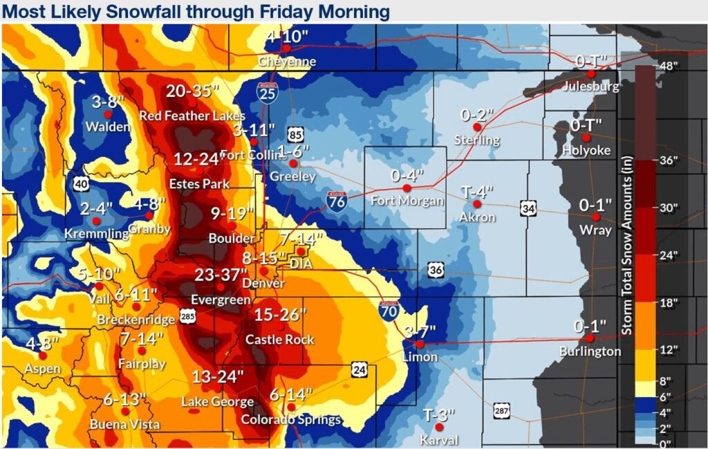
The National Weather Service is predicting 8 to 15 inches in Denver, with up to 20 inches in the western suburbs. Widespread ranges of 18 to 36 inches are expected in the mountains, with peak values near 4 feet. According to the National Weather Service, up to 2 to 3 inches of snow per hour is expected in the front range. Here are some predictions for specific locations.
- Boulder: The city 30 miles northwest of Denver is forecast to see 12 to 22 inches of snow Wednesday night with a chance of thunderstorms.
- Denver: The Mile High City could see its heaviest snowfall since March 2021, when 27.1 inches of snow fell. In addition to about a foot of snow, the forecast calls for thunderstorms and wind gusts up to 30 mph that could cause blowing and drifting snow.
- Evergreen: This Front Range town less than 40 miles southwest of Denver could see more than 100 meters Wednesday night, another 100 meters Thursday and several more after that. Temperatures will drop into the 20s and winds will gust up to about 30 miles per hour.
- Cheyenne, Wyoming: Across the Colorado border and about 160 miles north of Denver, Cheyenne sits near the edge of an area where heavy snow is expected. The forecast calls for winds of 4 to 8 inches, with gusts of 35 to 45 mph.
- Colorado Springs: Colorado Springs, about an hour south of Denver on Interstate 25, is another area with the potential for more abundant snow. Expect to receive 6 to 12 inches.
Snow should fall slowly from north to south as the storm moves away late Thursday through midday Friday.
Snowstorms are usually difficult to predict, and this one was no exception. Three factors in particular make this prediction difficult.
- Uncertainty about when rain will turn to snow: If the change is slower than predicted, rainfall could decrease, especially in lower elevation areas like Denver.
- Where the heavy snow area starts and ends: Snow amounts are expected to vary widely from west to east, with total amounts expected to peak at higher elevations and fall into the plateaus east of Denver. It is difficult to predict where falls will occur and where particularly heavy bands of snow will be concentrated.
- Unusual conditions: The National Weather Service in Boulder said in discussion that this storm's path is “typically unfavorable for large snowstorms,” but that other factors, such as the large amount of moisture available, should compensate. Stated. A more than ideal truck.
Despite the uncertainty, the National Weather Service concluded that “the likelihood of a major winter storm forming in or near the Front Range mountains and foothills is high.”
It's the peak of heavy snowfall
Unlike many places, late winter and early spring are the most snowy months in the Rocky Mountains and highlands.
Alaska-based climatologist Brian Brettschneider recently said: I shared the above image with X, March is the snowiest month of the year. Many of the areas threatened by this storm are included in the pink area, with March ranking as either the snowiest month or the second snowiest month.
Jason Samenow contributed to this report.


